
 |
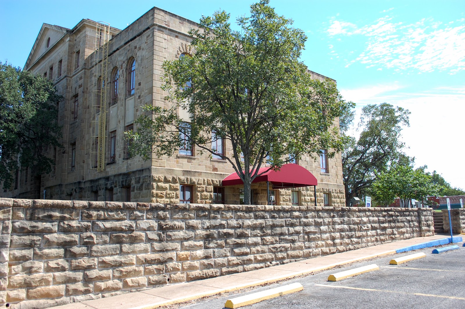
| Palo Pinto County Courthouse - 2017 Photo by K K R North |
Palo Pinto County is located in north central Texas. It’s center is eighty miles west of Fort Worth. The county was carved out of two other counties by the Texas State Legislature in 1856: Bosque and Navarro Counties. The county is named for Palo Pinto Creek. Some sources translate “palo pinto” as Spanish for “painted stick” while others translate it as “spotted stick”. Most agree, however, that the term refers to oak trees in the area which are “spotted” with colorful lichen.
 |
| Palo Pinto County Map. Courtesy of the Texas Almanac |
It was formally organized in 1857 and the town of Golconda was selected to be the county seat.
“Golconda” was a diamond center in India and, according to Webster’s dictionary, it means “a source of wealth, advantages, or happiness”. The citizens of Golconda renamed the town Palo Pinto in 1858.
Before the county was created, some of the big names in the cattle business all established ranches in this area: Charles Goodnight, Oliver Loving, George Webb Slaughter and Reuben Vaughn. Goodnight and Loving started the Goodnight-Loving Trail to New Mexico from here, while Slaughter drove cattle from his ranch to Louisiana. There is an Oliver Loving marker off of US 281 north of Mineral Wells. It is all that is left of Loving’s headquarters. G W Slaughter is the father of three other well-known cattlemen: Christopher Columbus “C C” Slaughter of the Long S Ranch; John B Slaughter and Will B Slaughter.
 |
| Charles Goodnight ca 1880 Photo is not under copyright. |
 |
| Oliver Loving Photo is not under copyright |
The town of Palo Pinto has never been very big. Although still the county seat, it’s population is currently only 330. I saw hardly a soul the day I was there. I spent much of my time standing in the middle of the road, framing my photo shots. Only one or two cars drove by.
The first courthouse was a frame building with a lean-to, built on the corner of the street south of the square. When in 1882 the Texas Legislature allowed counties to issue bonds in order to pay for the construction of courthouses, a larger sandstone courthouse was built in the middle of the square. This courthouse was levelled and replaced by the present courthouse in 1940.
The Palo Pinto County Historical Commission sponsors a self-paced driving tour each April which includes some locations that are usually not open to the public. I drove out that way this past April and visited each of the sites. They had folks at each point of interest to assist and answer questions. I especially appreciated the gentleman at the road to point out the turn off point to Lover's Retreat as I seriously doubt I would have found it if left on my own. The Old Jail Museum Complex was one of the places on the tour.
The first courthouse was a frame building with a lean-to, built on the corner of the street south of the square. When in 1882 the Texas Legislature allowed counties to issue bonds in order to pay for the construction of courthouses, a larger sandstone courthouse was built in the middle of the square. This courthouse was levelled and replaced by the present courthouse in 1940.
 |
Palo Pinto County's second courthouse.
Courtesy of the Palo Pinto County Historical Commission.
|
 |
| Palo Pinto County Courthouse, west side - 2017 Photo by K K R North |
 |
| Palo Pinto County Courthouse, west side - 2017 Photo by K K R North |
 |
Palo Pinto County Courthouse, south side - 2017
Photo by K K R North
|
 |
Palo Pinto County Courthouse State Marker - 2017
Photo by K K R North
|
 |
Map of Palo Pinto Downtown Square from 1872 to 1882 by Grace Perkins,
showing the location of the original Court House on the corner across from and southeast of the town square.
Courtesy of the Palo Pinto County Historical Commission.
|
The Palo Pinto County Historical Commission sponsors a self-paced driving tour each April which includes some locations that are usually not open to the public. I drove out that way this past April and visited each of the sites. They had folks at each point of interest to assist and answer questions. I especially appreciated the gentleman at the road to point out the turn off point to Lover's Retreat as I seriously doubt I would have found it if left on my own. The Old Jail Museum Complex was one of the places on the tour.
 |
| The Old Jail in Palo Pinto - 2017 Photo by K K R North |
 |
| Barred window on the Old Jail in Palo Pinto- 2017 Photo by K K R North |
 |
| Cells like those from the Old Jail in Palo Pinto - 2017 Photo by K K R North |
 |
| Detail on outer wall of Old Jail in Palo Pinto - 2017 Photo by K K R North |
 |
| Graffiti on outer wall of old Jail in Palo Pinto - 2017 Photo by K K R North |
 |
Noose and trapdoor on upper floor of Old Jail in Palo Pinto - 2017
I had to walk across the trap door to get this photo. A bit unnerving.
Photo by K K R North
|
 |
Jail Cell in Palo Pinto - 2017 Photo by K K R North
Looks a little different from the old western movies, doesn't it?
|
The jail was moved to the top floor of the courthouse in 1941. It was left vacant until 1968 when the Palo Pinto County Historical Commission restored it for use as a museum.
In addition to the old jail, there are other buildings brought to the grounds to form what is called the Old Jail Museum Complex, including a dogtrot cabin from the J R C Moseley Ranch; a two room cabin from the Rhodes Ranch; a blacksmith shop from the Maddox Ranch (it was originally the ranch kitchen); a carriage house and another cabin that was once owned by pioneer E N Barrows and his wife; and what may possibly be the oldest surviving structure in Palo Pinto: Fort Black Springs, a three story, stone building from Oran which travelers would use during “indian scares”. Horses were kept on the first floor while the military personnel were housed upstairs.
stone wall built around the museum complex was built as one of the Work Projects by the Civilian Conservation Corps in the 30’s. |
| J R C Mosely Ranch Log Cabin in Palo Pinto - 2017 Photo by K K R North |
 |
| Sign on building in Palo Pinto - 2017 Photo by K K R North |
Within walking distance of the Old Jail Museum Complex is the ‘downtown’ of Palo Pinto which doesn’t look much different today as it did when the downtown buildings were first built. The street running through the town on the south side of the courthouse is the old Bankhead Highway. Travelers going west would have seen the old Methodist church and adjacent gas station first, then rising above the town, they would have seen the courthouse and on the left the row of old frame business buildings. They could pass through literally in seconds, with their last sight another gas station, and then the town in their rearview mirror.
 |
| Buildings along the old Bankhead Highway on the south side of the Palo Pinto County Seat square. - 2017 Photo by K K R North |
 |
Using Grace Perkins' map above, this building is on the
site of the Mayhew Grocery in Palo Pinto
Photo by K K R North
|
 |
| And this was possibly on the site of the dry goods in Palo Pinto.- 2017 Photo by K K R North |
 |
The shoe shop (and later the barber shop) would have been in this location on the left
and the Smith Saloon on the right. - Palo Pinto 2017
Photo by K K R North
|
 |
| Detail of the business on the right - Palo Pinto 2017 Photo by K K R North |
 |
And this would have been the location of the Hunter &
Dillahunly Store. - Palo Pinto 2017
Photo by K K R North
|
 |
| Detail of the building above. Palo Pinto 2017 Photo by K K R North |
 |
| Doors of the building above. - Palo Pinto 2017 Photo by K K R North |
 |
Old gas station from a different angle with the Courthouse
in the background - Palo Pinto 2017
Photo by K K R North
|
 |
Old Methodist Church across the street from the
old gas station pictured above. - Palo Pinto 2017 Photo by K K R North
|
 |
Entrance to old Methodist Church - Palo Pinto 2017
Photo by K K R North
|
 |
Palo Pinto United Methodist Church sign - Palo Pinto 2017
Photo by K K R North
|
 |
Palo Pinto Methodist Church State Marker - Palo Pinto 2017
Photo by K K R North
|
 |
The site of the old M O Lynn General Merchandise according to
Grace Perkins' map above. - Palo Pinto 2017 Photo by K K R North
|
 |
Front view of building at the site of M O Lynn Merchandise - Palo Pinto 2017
Photo by K K R North
|
 |
Old abandoned gas station on west end of town. - Palo Pinto 2017
Photo by K K R North
|
 |
Compare this image to the 2017 photo of Palo Pinto shown above
and the one shown below. These all appear to be frame structures and the road is not paved.
Courtesy of Palo Pinto County Historical Association
|
 |
Another view showing the old gas station on the east end of town
on the left (with my Subbie!) You can see
how vacant it is on the weekend.- Palo Pinto 2017 Photo by K K R North |
Palo Pinto Cemetery
Just outside of Palo Pinto, on the west side of Hwy 4, is Palo Pinto Cemetery. A number of early pioneers are buried here. The first marked grave in the cemetery is George W Slaughter, the son of the famous rancher George Webb Slaughter and his wife Sarah. The son was born in 1847 and died in 1860. George Webb Slaughter and Sarah are also buried here as is a few other Slaughter family members, including W B Slaughter. Their graves are inside a heavy metal fence.
 |
| Slaughter family gravesites - Palo Pinto 2017 Photo by K K R North |
 |
| George Webb Slaughter gravesite - Palo Pinto 2017 Photo by K K R North |
Lover’s Retreat
 |
| Postcard of Lover's Retreat Suspension Bridge in my collection. |
A once-popular public park and favorite picnic spot called Lover’s Retreat lies four miles west of Palo Pinto. Located off of Hwy 180 in a secluded area a couple of miles north of the highway, it is beside Eagle Creek along a no longer accessible stretch of the old Bankhead Highway. Located on private property owned by Mrs Eloise Beckworth Davidson, Lover’s Retreat is opened to the public on one day every other April as part of an annual Palo Pinto Driving Tour. Mrs Beckworth Davidson is a descendant of Barney Carter who purchased the land in 1932. Her son Carter Beckworth is buried in a private cemetery near the creek.
Mrs. Beckworth Davidson was there greeting everyone that day. She is a very sweet woman and all of the work her family did to mow and clean up the area for visitors was apparent and much-appreciated.
Mrs. Beckworth Davidson was there greeting everyone that day. She is a very sweet woman and all of the work her family did to mow and clean up the area for visitors was apparent and much-appreciated.
There are many legends about how Lover’s Retreat got it’s name. One of the most popular is that of an Indian maiden and her lover who met there in secret in defiance of her father, the chief of the tribe.
In addition to it’s picnic popularity, it was also favored as a swimming and fishing spot. A small pedestrian suspension bridge allowed visitors to cross over to climb the boulders on the other side. For a time, Sunday Services were held in a large tabernacle there and the Palo Pinto County Old Settler’s Reunions were once held there.
Vandals burned the tabernacle down and there’s not much left of the old suspension bridge. It too was a victim to vandals. It’s largely due to continual vandalism that the family has shut off public access.
 |
The old suspension bridge at Lover's Retreat has suffered
from vandalism and neglect - Palo Pinto 2017 Photo by K K R North
|
 |
The old suspension bridge at Lover's Retreat -
Palo Pinto 2017
Photo by K K R North
|
 |
The final resting place of Carter Beckworth at Lover's Retreat -
Palo Pinto 2017 Photo by K K R North |
 |
| Lover's Retreat - Palo Pinto 2017 Photo by K K R North |
 |
| A view of Lover's Retreat - 2017 Photo by K K R North |
 |
The stretch of old Bankhead Highway leading to
Lover's Retreat. I found out that I had just missed
Dan Smith who wrote the book on The Bankhead Highway. Seems I'm always just missing him! - Palo Pinto 2017 Photo by K K R North |
OTHER TOWNS
Other towns in Palo Pinto County include: Gordon with a population of 492; Graford with 578; Mingus with 232; Santo with 445; Strawn with 652 persons and the largest by far, Mineral Wells with a population of 16,486.
MINERAL WELLS
 |
First Crazy Well pavilion in Mineral Wells.
Cutter's Guide to Mineral Wells, 1893
|
Mineral Wells is 14 miles east of Palo Pinto. It has a fascinating and rich history which I will cover in more detail in the next few posts. The town’s history began with the arrival of James Lynch and his family in the late 1870’s. He had a well dug which would eventually be found to have healing properties. Word spread and before too long, hundreds of people were camping out in tents on Lynch’s property. A town was laid out and more wells were dug; wells with names like the Crazy Well, the French Well, the White Sulphur Well, the Texas Carlsbad Well, the Lithia Well and the Sangcura Sprudel Well, among many others.
Bottled water and water crystals were shipped all over the world, advertised on local radio stations and affiliates.
Pavilions with dance floors, bowling alleys, billiard rooms, bath houses and drinking bars (water drinking, that is) cropped up all over town. People came from all over the country to “take the waters” in Mineral Wells. It even attracted the attention of Hollywood with visits by Roy Rogers, Judy Garland, Tom Mix, Ronald Reagan (when he was an actor), Clark Gable, Marlene Dietrich, Jean Harlow, the Three Stooges, Will Rogers as well as other famous personalities: Dr Charles Mayo, Jack Dempsey, Sam Rayburn, General Pershing, Elliott Roosevelt, Helen Keller, Lyndon Baines Johnson, Sam Goldwyn, Sammy Kay. Famous bands played at the hotels and pavilions: Jack Amlung, a young Lawrence Welk, Paul Whiteman and one of my faves, Glen Gray.
To accommodate the growing crowds, homes became boarding houses which the owners called “hotels”. They continued operating as such even after buildings specially designed to be hotels were built. Two of the most famous hotels of that era still stand today: The Crazy Water Hotel and The Baker Hotel. The Crazy Water Hotel was used as a retirement home for a time but is now unused. The Baker Hotel has been long-abandoned and is in serious decay. More about these hotels will be covered in coming Texas Tales, Trails and Rails posts.
The town’s decline began with the Great Depression in the 30’s, only forestalled for a time by the war and Camp Wolters, the military training base that was built nearby. The mineral water market suffered when visitors couldn’t afford to travel to Mineral Wells and when the FDA began to crack down on some of the medical claims the water and water crystals manufacturers were making. By the 1940’s, most of the water companies were closed down and the pavilions gone.
Today, the only water company still in operation selling Crazy Water from the mineral wells is The Famous Water Company on NW 6th street. They bottle the water and ship it to groceries and other outlets. In addition, locals visit The Famous Water Company daily to have containers filled with Crazy Water. And in keeping with tradition, the owners Carol and Scott Elder also operate The Crazy Bath House on NW 1st Ave which offers rooms for rent and the services of a massage therapist.
 |
The Famous Water Company, the home of Crazy Water - Mineral Wells 2017
Photo by K K R North
|
 |
| Famous since 1904 - Mineral Wells 2017 Photo by K K R North |
 |
The Famous Water Company - Mineral Wells 2017
Photo by K K R North
|
At the end of World War II, Camp Wolters was deactivated and the soldiers gone. It was reactivated in 1951 as Wolters Air Force Base and became Camp Wolters Army Base in 1956. It had another name change in 1963 when it became a helicopter training camp during the Vietnam War, becoming Fort Wolters. It was closed in 1973 and became Wolters Industrial Park.
As noted, Mineral Wells has a rich and fascinating history which I will cover in the next few Texas Tales, Trails & Rails posts.
In addition, I am working on designing a walking tour map of Mineral Wells to indicate where the wells, pavilions, hotels and bath houses were as well as current points of interest.
In addition, I am working on designing a walking tour map of Mineral Wells to indicate where the wells, pavilions, hotels and bath houses were as well as current points of interest.
STRAWN
Thirty-five miles south of Mineral Wells, on TX Hwy 16, is the tiny town of Strawn. Now a popular stop for motorcycle enthusiasts, eating at either Mary’s Cafe or Flossie’s, Strawn was once a coal mining town.
It was first named North Fork but was later re-named after a local rancher, Bethel Strawn who sold land to the railroad to encourage it to bring the train through the town.
The day I was there, I didn't see a single soul for 45 minutes while I photographed downtown and only a handful a autos drove through. Strawn has one of the most beautiful brick roads; the bricks undoubtedly from Thurber's long-closed brick factory although they had no markings.
Similar to nearby Thurber, Strawn had a company-owned mercantile that sold groceries, furniture, hardware, dry goods, stock feed and contained a meat market. The company had it’s own money which was accepted in local private stores as well as the company store. The money was in the form of brass and metal coins designated as five, ten, twenty-five, fifty cents and one dollar. Strawn even had some company-owned homes that employees rented.
Strawn became an oil town when the T & P Coal and Oil Company began drilling for oil in 1915. There were 20 oil wells in the area shortly after.
 |
Business section of Strawn looking west. Postcard. It doesn't look much different
today except for the road which was not paved at the time of this postcard.
|
 |
Strawn today with a beautiful brick road. Most likely Thurber bricks. - 2017
Photo by K K R North
|
 |
| Business in Strawn - 2017 Photo by K K R North |
 |
| Building in Strawn - 2017 Photo by K K R North |
 |
Building in Strawn. Another great look at the brick road. - 2017
Photo by K K R North
|
 |
You can see that the roof and back wall of the building on the right are missing.
But look at the beautiful brick road! - Strawn 2017 Photo by K K R North
|
 |
| Building in Strawn - 2017 Photo by K K R North |
 |
Business section in Strawn. Another wonderful view of the brick road. - 2017
Photo by K K R North
|
City Hall
 |
Strawn may be small but they have a beautiful City Hall. - 2017
Photo by K K R North
|
 |
| City Hall State Marker - 2017 Photo by K K R North |
 |
| Another marker at the City Hall - 2017 Photo by K K R North |
 |
Another marker at City Hall. A bit difficult to read.
Bethel Strawn was a leading citizen who the town was named after.
The marker also explains that a petroleum formation is also named after him.
|
The town also had an Opera House, a Theater, a cotton gin (also owned by the coal company), a flour mill, feed mill, four large saloons and at one time, had two movie air domes. The Bankhead Hotel was built in the 1920s to accommodate motorists along the newly completed Bankhead Highway. The building is now vacant but sits on the north side of the railroad tracks. I specifically wanted a photo of this lovely old building.
 |
| Bankhead Hotel - Strawn 2017 Photo by K K R North |
 |
| Bankhead Hotel - Strawn 2017 Photo by K K R North |
 |
| Bankhead Hotel - Strawn 2017 Photo by K K R North |
 |
| View of Bankhead Hotel across the railroad tracks - Strawn 2017 Photo by K K R North |
 |
| Rear of the Bankhead Hotel - Strawn 2017 Photo by K K R North |
The railroad depot once sat across the tracks from the Bankhead Hotel, but now sits across the road on the east side of the hotel. It closed in 1976. In recent years, it was restored by the Strawn Historical Museum Association.
 |
| The restored railroad depot - Strawn 2017 Photo by K K R North |
 |
| Info about the railroad depot - Strawn 2017 Photo by K K R North |
 |
I thought I had gotten a photo of one train framed by the
gate as it passed through but there were two trains! -
Strawn 2017 Photo by K K R North |
Strawn Historical Museum
Just steps away from the restored railroad depot is the tiny Strawn Historical Museum. It’s a one-room affair crowded with artifacts and historical documents.
 |
| Strawn's History Museum - 2017 Photo by K K R North |
Lovera’s Grocery / Strawn Market
Nearby is the Strawn Market. Opened in 1913 by Louis and Eugenia Lovera, the gas and grocery convenience store was moved in 1930 to it’s present location to be closer to the highway. Sadly, Eugenia and her son died in 1918 during the Spanish Flu epidemic, just 48 hours apart. Mr Lovera continued operating the store until he died in 1936. His children continued to run the store until selling it in 1974. The store is now owned by Cathy Brown and has been renamed Strawn Market.
Mount Marion Cemetery
Less than half a mile on the south side of the tracks, is the Mount Marion Cemetery. It got it’s name from the coal mine that was sunk in Strawn, Mt Marion.
 |
| Entrance to Mt Marion Cemetery - Strawn 2017 Photo by K K R North |
Robinson Schoolhouse
Five miles north of Strawn on Hwy 16 is a one-room brick schoolhouse. Fully restored and open for viewing by appointment only, the Robinson Schoolhouse was once recognized as the “smallest school in Texas”. In 1937, in protest of high school taxes, Guy Robinson petitioned the county to build this school. It was in use until 1943 with only two students left attending.
 |
| Robinson School House state marker - near Strawn 2017 Photo by K K R North |
 |
| Approach to Robinson School House -near Strawn 2017 Photo by K K R North |
 |
Robinson School House. It's definitely a one-room school! -
near Strawn 2017 Photo by K K R North |
 |
| Robinson School House - near Strawn 2017 Photo by K K R North |
Zim’s Cafe
Zim’s Cafe is located on the west side of Hwy 16 just a few miles north of Strawn. Re-opened in April 2017 as a farmers market, craft market and cafe, Zim’s Cafe has a unique history. The building and other properties at this location were built in the 1920s by an imaginative and enterprising Marche (MARCH-EE) “Zim” Zimick. Zimicki (originally Zamitzski) was born in Pennsylvania in 1897 and moved into the area with his folks to work in the coal mines, first working in Thurber around 1900, then moving on to nearby Lyra by 1910.
Regrettably, the café was closed for the day by the time I made my way down the highway to find it. This, of course, calls for another trip to Strawn.
Regrettably, the café was closed for the day by the time I made my way down the highway to find it. This, of course, calls for another trip to Strawn.
 |
| Zim's Café - near Strawn 2017 Photo by K K R North |
 |
| Zim's Café - near Strawn 2017 Photo by K K R North |
After World War I, Zim returned to the area and purchased 20 acres and began building. He had help from former coal miners in the area. His Zim’s Quality Beverages provided “fuel-eats-drinks & ice” to those traveling Hwy 16. On site was a gas station, restaurant, ice house, bar, dance hall, large machine shop, motor court for overnighters and even both a Dr Pepper Bottling Plant and a Coca Cola Bottling Plant. There was even a private power plant to supply electricity.
The story goes that Zim lost the Coca Cola franchise when he refused Coca Cola’s request to stop using his well water in favor of Strawn’s city water.
From Hwy 16, Zim’s appears to be a one-story building but what the traveler sees from Hwy 16 is the second floor. The ground floor faces the west. In the rear, was a bocci ball court and a picnic area with barbeque pits.
To the south of the the bottling plants, Zim built a two-bedroom frame home which they lived in until they built a two story brick home in 1960 next to it. The brick home is still standing.
The brickwork was done by Zim’s father-in-law, Pete (“Piotr) Wasieleski. “Atop gentle wall arches facing the highway, three small round brick parapets crown each capital (think a rook in chess), their symbolism lost to time. The tumbled burgundy bricks lend the building a warm glow in morning sunlight. Ornate arched brick drains and soldiered brick accents above windows reveal artistry uncommon today.”
When the Bankhead Highway was completed in the 1930s, business dwindled and Zim went into ranching. In 1937, M L King bought the Dr Pepper Bottling franchise from him and moved it to Ranger.
The current owners of Zim’s Cafe are Gary Cunningham and Diana Barrett.
MINGUS
I had thought Strawn was small and vacant, but Mingus was even more so. I never even saw a single soul, although I saw some vehicles at a small gas station.
Named for William Mingus, an 1856 settler, the town is five miles east of Strawn on Highway 108. It was a farming and ranching community, it’s population never topping more than 1,110.
Some of the first settlers included J. R. Graves, Frank Bolen, B. H. Stewart, and A. T. Crawford. The population declined when the T & P Coal and Oil Company closed down the coal mines in Thurber in 1933.
 |
Mingus in better days.
Is that the State Bank that is being built in the background?
Photo courtesy of the Palo Pinto County Historical Commssion
|
In the 1960s and 70s, Mingus gained popularity as a “wet” town, providing liquor in a number of stores and bars for the surrounding “dry” areas in Palo Pinto and even surrounding counties. John Clay and the Lost Austin Band wrote a song about Mingus called “The Road to Mingus (a cautionary tale)”. The song is about three young beer drinkers travelling from Strawn to Mingus for beer and on the return trip home, they are challenged to a race by a “little old lady” who they give a head start “because she was a lady”. She crossed the railroad tracks ahead of them and in trying to outrun the “Katy”, their ‘39 Ford is smashed up by the train.
The town is practically deserted today. There is a small post office and some abandoned buildings, including an old grocery, the State Bank, the old Texas Hotel and a badly-weathered frame Baptist church. A local honky-tonk seems to be the only activity in “town”.
 |
Old building in Mingus. The one on the left is vacant but once was the State Bank.
The one on the left appears to be a occupied. - 2017 Photo by K K R North
|
 |
The old State Bank. Now vacant. Mingus 2017
Photo by K K R North
|
 |
| Across the street from the old State Bank - Mingus 2017 Photo by K K R North |
 |
| The old Texas Hotel in Mingus - Mingus 2017 Photo by K K R North |
 |
| The old Texas Hotel in Mingus - Mingus 2017 Photo by K K R North |
 |
Old Baptist Church in Mingus - 2017 Photo by K K R North
It had such a small 'parking lot', I wondered how many people
could attend and then I realized, in those early days, fewer
people had cars and most likely were within walking distance.
|
As mentioned, my next few posts will be about Mineral Wells' history, specifically the wells, pavilions, hotels and bath houses that make this town both unique and historic.
2017 Copyright. K K R North, Texas Tales, Trails & Rails
All photos attributed to K K R North can be used for non-commercial purposes without prior notification with only the request to please credit K K R North as the photographer. Thanks!
References:
Handbook of Texas Online, John Leffler, "Palo Pinto County," accessed November 04, 2017, http://www.tshaonline.org/handbook/online/articles/hcp01.
Miller, Ray. Eyes of Texas Travel Guide. Cordovan Corp., 1981.
Johnson, Margie. “Old Jail Museum Complex.” Palo Pinto County Historical Commission, Palo Pinto County Historical Commission, 2011, www.palopintohistory.com/special-places/18-old-jail-museum-complex.html.
“Texas Almanac - The Source For All Things Texan Since 1857.” Palo Pinto County | Texas Almanac, Texas Almanac, 21 May 2015, texasalmanac.com/topics/government/palo-pinto-county.
Ervin, Bill. “Palo Pinto County History.” Palo Pinto County Historical Commission, Palo Pinto Historical Commission, www.palopintohistory.com/history.html.
Walker, Kay. “Palo Pinto Co., TX - Cemeteries: Palo Pinto Cemetery.” USGenWeb Archives - Census Wills Deeds Genealogy, USGenWeb Archives, 1974, files.usgwarchives.net/tx/palopinto/cemeteries/palopinto.txt.
Gibson, Barclay. “STRAWN, TEXAS.” Strawn Texas., Texas Escapes, www.texasescapes.com/TexasTowns/Strawn-Texas.htm.
Martin, Joe. “Texas Tabernacle by Jeff Clark.” The Strawn Sand by Joe Martin, Texas Tabernacle, 1 Jan. 1970, texastabernacle.blogspot.com/2014/03/the-strawn-sand-by-joe-martin.html.
Johnson, Margie. “History of Strawn Train Depot.” Palo Pinto County Historical Commission, Palo PInto County Historical Commission, 2015, www.palopintohistory.com/special-places/23-history-of-strawn-train-depot.html.
Chesnut, JIm. “Country Commentary.” Jim Chesnut Country Commentary, Chesnut Productions, www.chesnutproductions.com/countrycommentary.htm.
Smith, Billy B. “DELIGHTFUL DETOUR.” Delightful Detour., Texas Escapes, 17 Nov. 2007, www.texasescapes.com/TRIPS/Delightful-Detour.htm.
Clark, Jeff. “Zim Zimicki's Hard Work Fuels America's Trip West.” MicroplexNews.com, Microplex News, 25 Feb. 2011, www.microplexnews.com/zim-zimickis-hard-work-fuels-america%E2%80%99s-trip-west/.
Handbook of Texas Online, William R. Hunt, "Mingus, TX," accessed November 07, 2017, http://www.tshaonline.org/handbook/online/articles/hlm74.


No comments:
Post a Comment
Want to comment?